| | | The public comments received during the February 2019 public meeting comment period included concerns related to residential relocations and environmental impacts, including habitat fragmentation and impacts to water resources. Given the large amount of public opposition to T-1 and support for improving existing roadways between Robbinsville and Andrews, it was determined that scenarios T-1 and T4 would not be studied further as part of the A-0009C project. | 10 | corridor-k-faqs | | Approved |
| | | The study corridors presented at the February 2019 public meetings and the Improve Existing Alternative were evaluated during the NEPA process. The project team evaluated potential new scenarios suggested during the public comment period.
After additional coordination with local officials and agency representatives, the Improve Existing Alternative and No-Build Alternative were carried forward as detailed study alternatives. The Improve Existing Alternative was selected as NCDOT’s Preferred Alternative. Additional information is included in the Environmental Assessment. | 20 | corridor-k-faqs | | Approved |
| | | Many comments received during the February 2019 public meeting comment period expressed concern over property impacts associated with T-1, with others expressing concern over S-2, S-6, or general concerns about impacts to businesses and homes. (T-1 was not studied as part of the A-0009C project.)
The study corridors shown at the February 2019 public meetings were evaluated during the NEPA process in an effort to avoid and minimize impacts to existing development. The study corridors are wider than what would be the actual footprint so the roadway alignments can be adjusted to find a “best fit” that avoids and minimizes impacts to existing residences, businesses, natural resources, and cultural resources. The Environmental Assessment presents impacts based on preliminary designs of the Preferred Alternative (Improve Existing Alternative). Efforts to minimize anticipated impacts will be further evaluated during the final design phase.
| 30 | corridor-k-faqs | | Approved |
| | | New location options T-1 and T-4 were not studied further as part of the A-0009C project.
After the February 2019 public meetings, field biologists, geologists, engineers, architectural historians and archaeologists conducted field surveys for use during the NEPA process. These studies included protected species evaluations, stream and wetland delineations, visual impact assessment, air and noise studies, and cultural resource surveys. After field surveys were completed, alignments were refined to avoid and minimize impacts to environmental resources. Other measures, such as retaining walls and slope adjustments were evaluated to further reduce impacts.
Potential impacts to the Appalachian Trail and ways to avoid or minimize those impacts were studied in the NEPA process, in cooperation with National Parks Service, the U.S. Forest Service and the Appalachian Trail Conservancy. After stream and wetland impacts are avoided and minimized to the maximum extent practicable, any remaining impacts will be addressed through compensatory mitigation measures.
The Environmental Assessment includes links to the technical studies conducted during the NEPA environmental review process and detailed information on agency and stakeholder coordination. | 40 | corridor-k-faqs | | Approved |
| | | Over the past few months, surveyors have been verifying aerial mapping so the project team can have accurate information on the location of homes, businesses, utilities and other human-built features in the project study area. Survey work for the Preferred Alternative is ongoing and anticipated to be completed in spring 2021.
Please contact the project team if there are cemeteries, wells, or any other features that you feel we should be aware of. Sites of a sensitive nature will not be made available to the public.
| 50 | corridor-k-faqs | | Approved |
| | | The purpose is to provide the transportation infrastructure necessary for the well-being of local residents by improving mobility and reliability between the existing four-lane section on N.C. 28 at Stecoah and U.S. 129 in Robbinsville. | 60 | corridor-k-faqs | | Approved |
| | | The goal is to find a "right-size" design that can best address transportation needs while minimizing impacts. The lanes included in the NCDOT Preferred Alternative, as shown in the Public Hearing maps, were determined by the results of traffic and design studies. The Preferred Alternative is three lanes (one lane in each direction plus a passing or climbing lane). There is a four-lane section at the Appalachian Trail/Stecoah Gap area, where there is a climbing lane in each direction. | 70 | corridor-k-faqs | | Approved |
| | | The
project is federally funded through the Appalachian Regional Commission
and dedicated to the Appalachian Development Highway System Additional
federal funding may be available by competing for national discretionary
grants, such as BUILD and INFRA. | 80 | corridor-k-faqs | | Approved |
| | | An Environmental Assessment (EA) was prepared, which describes the range of alternatives evaluated in the NEPA environmental review process and identifies the NCDOT Preferred Alternative. Measures to avoid and minimize impacts to the human and natural environment were considered during development of the EA. As the proposed project advances and final designs are developed for the Preferred Alternative, additional design refinements will be evaluated to further minimize impacts.
Final design will begin after a public hearing in October 2020, additional coordination with regulatory and resource agencies, and publication of an anticipated Finding of No Significant Impact (FONSI).
It is anticipated construction from Robbinsville to Stecoah will be done in three sections. See the project schedule for additional details on next steps.
| 90 | corridor-k-faqs | | Approved |
| | | Those with questions and comments can send a message, or contact Wanda Austin at (828) 631-1148 or Stacy Oberhausen at (919) 773-8887, ext. 116. | 100 | corridor-k-faqs | | Approved |
| | | The N.C. Department of Transportation is studying possible upgrades to the current I-440 (Raleigh “Beltline") at Glenwood Avenue interchange in order to accommodate high traffic volumes and future growth in the area. The project also includes improvements at the intersection of Glenwood Avenue and Blue Ridge/Lead Mine roads and the replacement of the bridge on Blue Ridge Road over Crabtree Creek. | 10 | i-440-glenwood-faq | | Approved |
| | | The intent of the project is to address congestion and safety concerns at the I-440/Glenwood Avenue interchange and at the intersection of Glenwood Avenue and Blue Ridge/Lead Mine roads. In addition, the project also includes the replacement of the state-maintained bridge No. 494 on Blue Ridge Road over Crabtree Creek, which NCDOT had previously identified as needing replacement. NCDOT will also consider improvements to bicycle and pedestrian connections and ways to support transit operations in the Crabtree Valley area as part of the project. | 20 | i-440-glenwood-faq | | Approved |
| | | Originally constructed in the 1960s (and upgraded in the 1990s), the Glenwood Avenue interchange on I-440 cannot handle the volume of traffic that uses the interchange today. Additionally, forecasted growth in the region is expected to result in more congestion and to worsen traffic flow at the interchange and on surrounding roadways. The existing roads can only handle a limited amount of traffic before drivers experience problems; since the amount of traffic is expected to increase in the future, these limits create safety issues and congested conditions for drivers that need to be addressed. | 30 | i-440-glenwood-faq | | Approved |
| | | The City of Raleigh's 2011 Crabtree Valley Area Transportation Study: Vision for the Valley identified transportation-related needs in the Crabtree Valley area and recommended a number of improvements to address these needs. With the information in this study, the city, working with the Capital Area Metropolitan Planning Organization, recommended the I-440 at Glenwood Avenue project for funding in the NCDOT State Transportation Improvement Program (STIP).
Although the 2011 city report enabled NCDOT to include the project in the STIP, the current project will use an entirely new set of data to identify the critical needs within the area being studied around the interchange and to assess potential options.
The NCDOT study of I-440 at Glenwood Avenue began in late 2017 and includes an updated set of traffic, environmental and community studies and analyses, as well as extensive outreach to stakeholders and community members.
Although the 2011 city report provides useful background information, NCDOT will rely on the new studies and public input to develop project concepts and to assess their potential impacts. | 40 | i-440-glenwood-faq | | Approved |
| | | NCDOT is following a structured planning process to collect data, develop transportation design options and assess the impacts of those options; and will ultimately prepare a federal environmental document that summarizes this effort. For this report, the various technical studies evaluating current and future traffic, environmental and community conditions and potential project impacts will be combined into an environmental analysis that compares the social, economic and environmental impacts of the design options that are developed. All public feedback received during the project study will be incorporated into the analysis, and NCDOT will use all this information to recommend an alternative that best meets the overall needs identified while balancing the potential benefits and impacts. 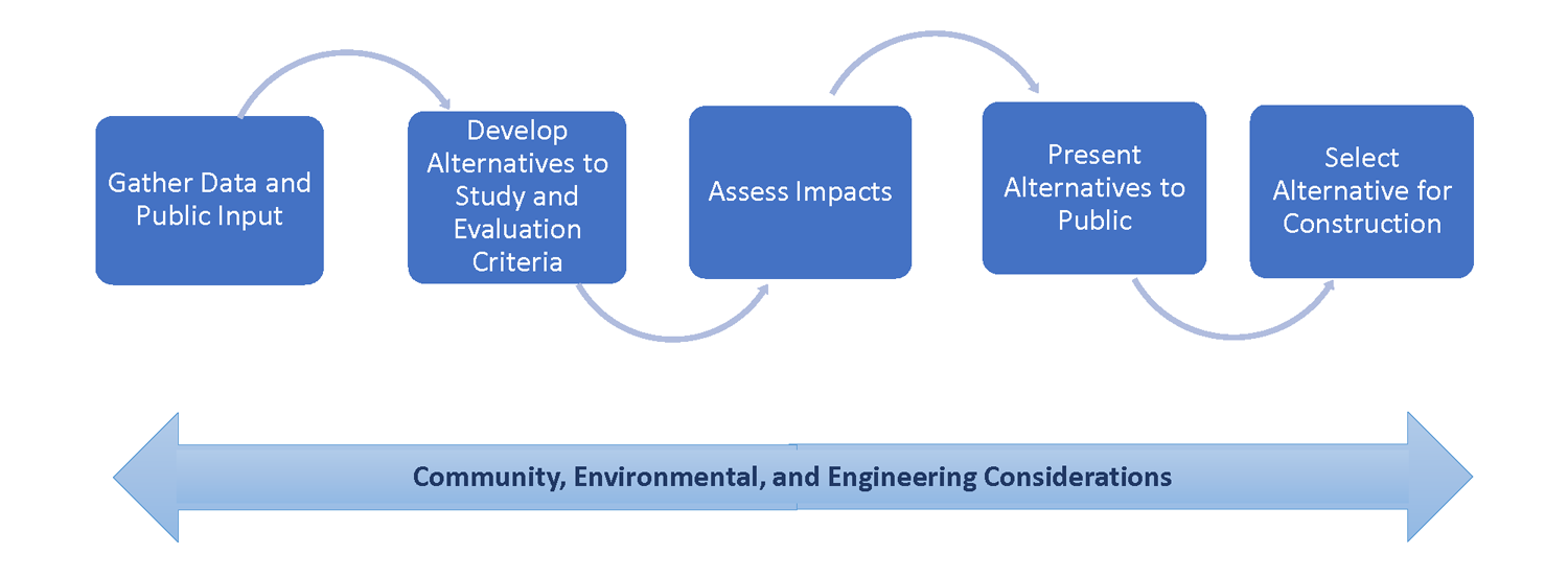 | 50 | i-440-glenwood-faq | | Approved |
| | | At the start of the project effort, NCDOT identified a “study area" to represent the area where physical changes might occur as a result of the project.
As part of the study, NCDOT and the consultant team will gather data on all the characteristics of this study area- including the natural, cultural, and community resources. However, to understand the full impact of the project, NCDOT looks at a much larger area to determine the project's impact to local and regional traffic patterns, as well as the broader community. | 60 | i-440-glenwood-faq | | Approved |
| | | When reviewing the traffic information for the project area, NCDOT concluded that improvements to the existing interchange at I-440 and Glenwood Avenue might require the construction of auxiliary lanes on both sides of I-440 between Glenwood Avenue and Lake Boone Trail. These lanes will only be constructed if the design option selected for the project requires them in order to address congestion issues at the I-440 and Glenwood Avenue interchange.
At this time, NCDOT is only collecting data about the additional study area; a decision about whether these auxiliary lanes will be needed will be made when a preferred design option is selected. | 70 | i-440-glenwood-faq | | Approved |
| | | When deciding on the preferred design for the project, NCDOT must consider the impacts (either beneficial or adverse) to the following: Natural resources (wetlands, water quality, wildlife, habitats, endangered species) Cultural resources (historic architectural properties, archaeological sites) Community resources (businesses, neighborhoods, schools, parks, greenways, etc.) The public, including multimodal users and vulnerable populations Current and projected land use Flood plains Noise and air quality conditions Traffic and safety for vehicles, pedestrians, bicyclists and transit riders
Studies conducted for this project will assess the potential impacts of various possible transportation solutions and will include recommendations on how to avoid, minimize or mitigate for potential impacts. | 80 | i-440-glenwood-faq | | Approved |
| | | Existing sidewalks, bicycle lanes and greenways impacted by project improvements would be replaced as a part of the project.
NCDOT will also assess whether additional pedestrian and bicycle facilities would address current safety issues and mobility challenges and therefore be constructed as part of this project, working closely with the City of Raleigh, to reflect their vision for multimodal facilities in the area.
Bus transit routes and facilities will also be considered as part of the project planning and design process. | 90 | i-440-glenwood-faq | | Approved |
| | | NCDOT is well aware of the flooding that occurs along Crabtree Creek during storm events, and the project's potential to impact the existing flood plain is a major consideration. As design options are developed, the project team will use a detailed computer model of the study area to determine whether the design options will increase flooding during storm events.
Options that increase the potential for flooding will not be considered. NCDOT will also investigate design measures and treatment options that further minimize the impacts of stormwater runoff within the study area. | 100 | i-440-glenwood-faq | | Approved |
| | | Stakeholders are individuals and organizations who have interests in the project area. These include people who live, work, travel through or visit the project area.
Stakeholders might have interests that could be affected as a result of project construction or project completion – whether these include a business or home that could be impacted by project construction or a driver that uses the streets within the project area for getting to work, shopping or services.
NCDOT held several stakeholder meetings in 2018 that focused on those organizations and groups of individuals most likely to be directly affected by the project. | 110 | i-440-glenwood-faq | | Approved |
| | | Public input will be key in developing design options, assessing the impacts of those options, and recommending an alternative for construction.
NCDOT will need input on the public's concerns. For example, how does the project affect your property? How does it affect your ability to travel within or in/out of your neighborhood? Does it impact areas or features (parks, schools, greenways, churches, businesses) that are important to you?
The collective public input is important and is fully considered in deciding what will be constructed. | 120 | i-440-glenwood-faq | | Approved |
| | | The NCDOT study of I-440 at Glenwood Avenue began in late 2017. The project team collected extensive data, conducted field reviews and prepared technical reports to document existing transportation, community, environmental and physical conditions in the area.
NCDOT held meetings with resource and regulatory agencies, local transportation staff and project area stakeholders in the spring and summer of 2018. NCDOT held three listening sessions in September 2018 to gather specific feedback and concerns about the project from neighborhoods and communities.
The input from all the stakeholders, along with the data about the study area, will be used to develop design options for the project.
Public meetings and additional outreach will be scheduled in 2019 to provide the public with an opportunity to review the initial design options.
Comments received at these meetings will be used to narrow down the options to those that will receive even more in-depth consideration.
The final decision on the design option to be constructed will be made following completion of all technical studies and additional public outreach.
As part of an overall departmental effort to balance the available funds for projects statewide, NCDOT recently adjusted the project schedule such that construction is now expected to begin in 2025. | 130 | i-440-glenwood-faq | | Approved |
| | | The current budget for the project, which includes costs for improvements at the I-440 and Glenwood Avenue interchange as well as the intersection of Glenwood Avenue and Blue Ridge/Lead Mine roads, is approximately $237.1 million.
Updated cost estimates will be developed for the project as part of the current study process, and this information will be provided to the public during future public meetings. | 140 | i-440-glenwood-faq | | Approved |
| | | This project is being managed by NCDOT. NCDOT has engaged a team of consultants to study the project area, develop design options and complete the final environmental analysis for the project. All of the consultants working on the project report to NCDOT. | 150 | i-440-glenwood-faq | | Approved |
| | | NCDOT has been working closely with the City of Raleigh since the start of the project study. City representatives provide important feedback on the transportation needs within the area as well as the community sentiment about the project. The city will remain involved throughout the project's development and construction. | 160 | i-440-glenwood-faq | | Approved |
| | | Please feel free to send a message to NCDOT project manager David Stark, P.E., using this online form, or send a message to consultant project manager Beth Smyre, P.E., at
esmyre@dewberry.com. | 170 | i-440-glenwood-faq | | Approved |
| | | You can subscribe to the mailing list through
NCDOT's public input portal. It also provides project information updates and an opportunity to provide input, including several questions regarding transportation needs and community resources and an open-ended question for any other information that you would like to share. | 180 | i-440-glenwood-faq | | Approved |
| | | Construction is expected to last about four years. In August 2019, the contractor started some work on the project. The I-77 bridge work is expected to begin in September 2019.
| 10 | i-40-77-interchange-faq | | Approved |
| | | Signal Hill Drive is being realigned to improve traffic flow at the Signal Hill Drive and East Broad Street intersection. | 20 | i-40-77-interchange-faq | | Approved |