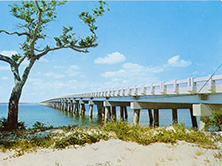
 The three-mile Umstead Bridge (Dare County Bridge 9) built on U.S. 64 by the State Highway Commission in 1955-1956 to connect the mainland with Roanoke Island (Durwood Barbour Collection of North Carolina Postcards, UNC-Chapel Hill)
 Although the Roanoke Colony on Roanoke Island was the first attempted permanent English settlement in the New World, the low-lying islands and shallow waters so treacherous to navigation long made the Outer Banks one of the most isolated and sparsely settled areas along the East Coast.
Access was available only by water transport. By 1900, development was limited to a handful of small villages, tiny resort towns such as Nags Head, and the stations established by the United States Life-Saving Service.
By the 1920s it was increasingly obvious to local developers that the future of the Outer Banks as a tourist destination was tied to improving highway connections with the mainland. But they had little influence with the State Highway Commission, and all their proposals for bridges were turned down as too costly. The Commission was focused on improving the system of primary highways on the mainland and not ready to reach out to the barrier islands, a situation that didn't change until the 1950s.
Local businessmen initially took matters into their own hands by forming private toll bridge companies. In 1928 the Baum Bridge (replaced in 1951) was built in Dare County over Roanoke Sound between Roanoke Island and the beach. This was followed in 1930 by the Wright Memorial Bridge (replaced in 1966) that carried N.C. 158 over Currituck Sound and truly opened the islands to development.
The Great Depression slowed development, but after World War II and into the 1950s the Outer Banks became the tourist destination developers had long envisioned. The State Highway Commission began taking an increasingly active role, especially after buying the toll bridges and making them free.
The second span to connect the islands and the mainland was the William B. Umstead Bridge (Dare County Bridge 9), erected by the State Highway Commission in 1955-1956 to carry U.S. 64 over the Croatan Sound. At nearly three miles, it was the biggest state bridge project of the 1950s, based on overall length and expense, but the crossing posed few major technological challenges. The bridge was formed of an extensive series of conventional steel stringer and girder-and-floorbeam spans, none of which extended more than 130 feet.